
Feedback


Feedback
About FMDA
Faridabad Metropolitan Development Authority. Any area falling with the limits of controlled areas in Faridabad District to be notified area having potential for urban expansion.
Our Mission
To be a major support in governance by embedding GIS in all aspects of decision making, planning & management.
Our Plan
More detailed & acccurate Geo-enabled Decision Support Systems aligned with objectives of development of the state.
Our Vision
Reforming the government to increase effectiveness of land acquisition, planning, compensation, providing urban services.
GIS WEB APPLICATIONS
Following GIS Applications Developed by FMDA that accelerate the GIS Infrastructure in Faridabad.
Land Governance
Land Ownership, Search Khewat & Khasras, Jamabandi Details, Control Points
Properties
Property ID, Property Tax Bill, Grievance, Property Search by Address or Name
Upcoming Infra.
Proposed Metro Line, Roads, CCTV Network, Water Boosting Station & more...
Image Services
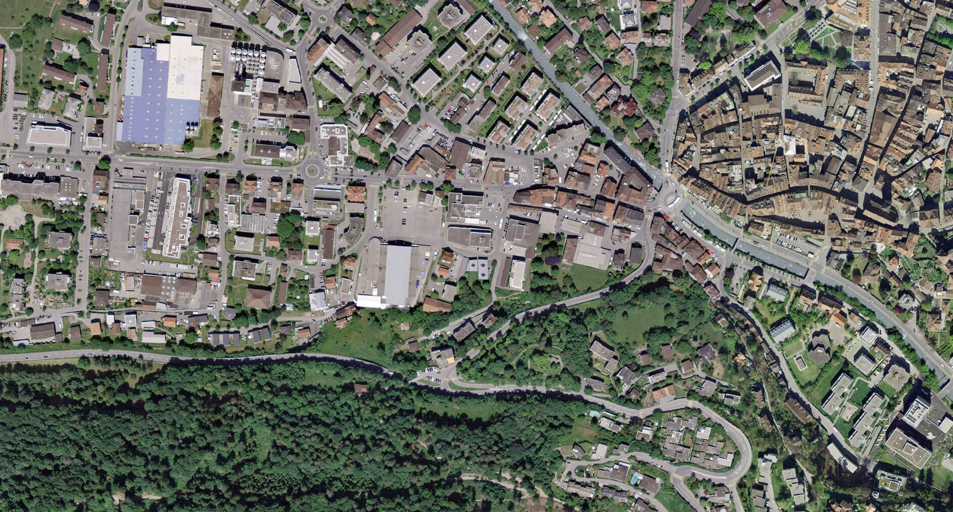
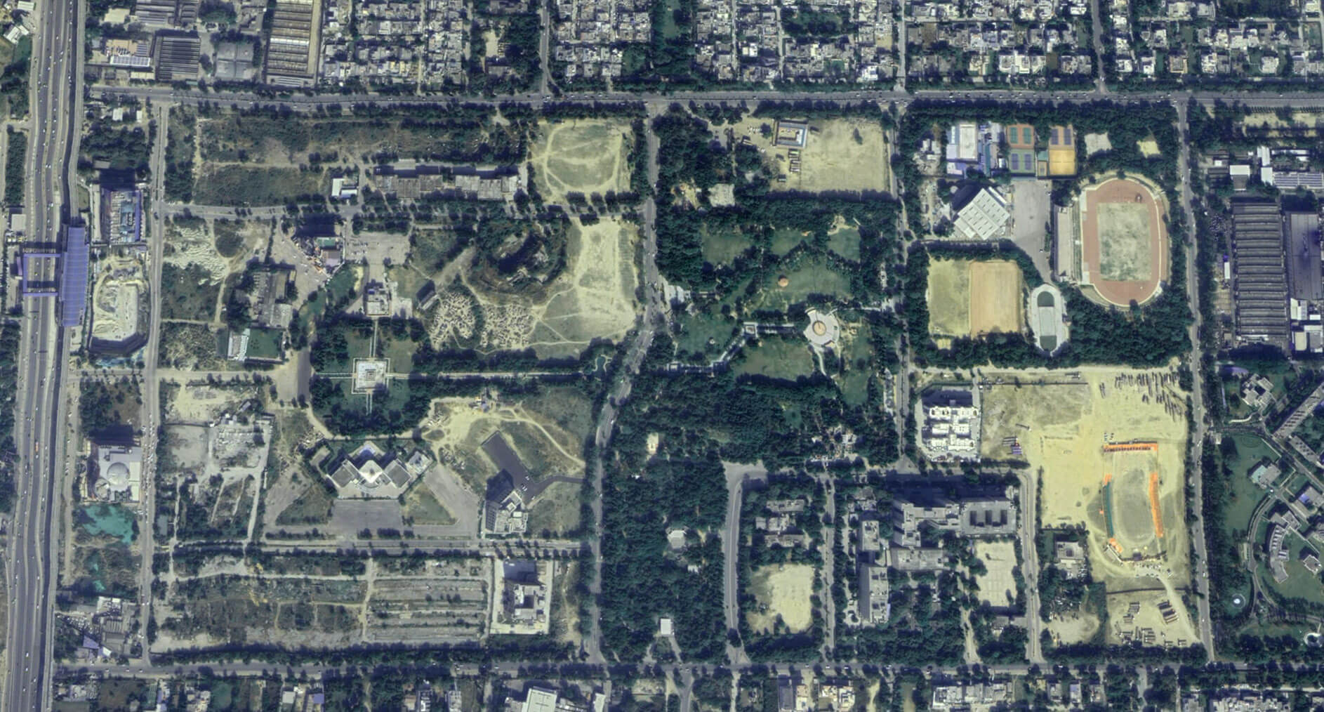
Change Detection of City Faridabad and Gurugram District Using Satellite Data.
Smart City
Promotion of eco-friendly mobility,Revival of open green spaces,Reducing road congestion,Connected, accessible and safe city,Smart and sustainable infrastructure.
Dashboards
Android Apps
UPCOMMING
Vehicle Tow App
MCF Challan App
App for Health Department (Official)
App for Road Survey (Official)- Beta Version
Smart City
Projects
Cadastral & Land Record Mapping For Ease Of Doing Business In Haryana
Dashboard For Haryana Crop Survey
Dashboard For Haryana Crop Analytics
Dashboard For Haryana Crop Image Classification
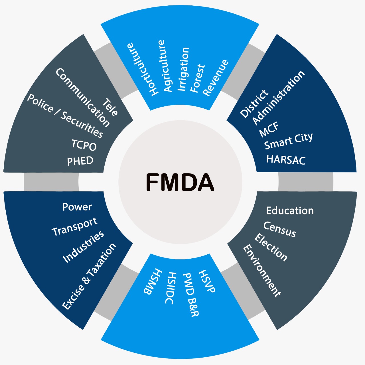
Integrated Departments
GIS Implementation in FMDA Allied Departments
OneMap Services
OneMap provides major support in governance by embedding GIS in all aspects of decision making in the FMDA, bringing transparency and geo-spatial information support in decision-making, enable a sound process of monitoring development and identifying “gaps in development, planning, management and decision making". Make GIS data available at all levels –that helps bringing accountability and responsibility in governance.
GIS Facilities Shared with GMDA
A Geospatial lab under GIS Division FMDA has been established to provide facilities related to latest geospatial technologies which are available in the market which includes cloud based servers & high end work-stations for image processing, data interpetation, analysis & results.
Server
High-end Cloud based servers (with 256 GB Ram, Intel Xeon 16 core processor & GPU graphics) established for database management, web hosting, data creation & web development.
Workstation
High Configuration workstations (with 256GB Ram, Intel xeon 16 core processor & GPU graphics) are available for performing various day to day activities related to geographical information system (GIS), remote sensing & other Geo-development activities.
Plotter & Printer
A high speed plotter of size A-0 is available for printing & scanning of large size maps for study & planning purposes.
Surveying Devices
GIS mobile application based tablets are available to perform activities such as data collection, surveying and ground truthing of data to accurate results.
Softwares
An End user license aggrement(ELA) for unlimited user licenses user FMDA jurisdiction has been performed with ESRI with complete software & server packages for smooth functioning of geospatial activities.
Geospatial Personnel
A team of Geospatial experts is working inhouse for performing Geospatial activities related to data creation, planning, analysis & development to provide an end user work with ease.
GIS DATA AT A GLANCE
AREA OF FARIDABAD METROPOLITAN DEVELOPMENT AUTHORITY
Total area of FMDA/District 743 square kilometers covers 192 villages
Total area with MCF limit : 290.56 Sq Km.
Total area under FMDA excluding MCF area : 452.44 Sq Km.
DEVELOPMENT PLAN WISE AREA
Area under FDP-2031 AD Faridabad : 638.06 Sq Km.
Area under MCF : 290.56 Sq Km.
Area under FMDA : 347.50 Sq Km.
Area under DDP-Mangar : 104.84 Sq Km.
Current GIS Layers generated by the GIS Division of FMDA
147+
GIS Layers Data
6.6+Lac
Total Features Data
23+
Boundaries
2684+Km.
Road Network
396+Km
Water Network
273+Km
Drainage Network
203+Km
Sewerage Network
86+Km
Storm Water
50+Km
Recycle Water
343+Acres
Building/Structure
620+Sq.Km
Land Use/Cover
70+
Hospitals
17244+
Industries
1630+
Tubewell
590+
Water Body
5+
STP
POPULATION DATA
Total Population of Faridabad 22,89,296
1,79,195+
BALLABGARH BL
1,23,631+
FARIDABAD BL
18,87,970+
FARIDABAD MC
98,409+
TIGAON BL
GIS Clause
Major activities and act clause used in FMDA bill for role of GIS in development plan
| # | FMDA Act Clause | Activity |
|---|---|---|
| 1 | Powers, functions and duties of Authority. (16.2.e) | Establish a modern geospatial based system for planning purposes and for land, infrastructure, urban amenities and urban environment in the notified area; |
| 2 | Definitions (2.1.f) | “geospatial based system” means processes and technology used to acquire,manipulate, plan and store datasets and information that identifies
geographic location, characteristics and other attributes of natural or constructed features in the notified Area and includes –
(i) boundaries of natural or constructed features and jurisdictions; (ii) statistical data; (iii) information derived from, among other things, mapping, remote sensing and surveying technologies; |
| GIS serve Infrastructure as a Services to Other Notified Area as follows | ||
| 3 | Development Plan (2.1.i, 11.3) | Facilitating in preparing GIS based master plan for Road, Water Supply, Sewerage, Drainage, Electricity, Sanitation |
| 4 | Mobility Management Plan (2.1.n) | Managing mobility in the notified area. Which includes improvement and construction of roads, bridges, pedestrian footpaths, subways. Enhancing safety of life and prevention of accidents on public roads. Measures in regard to public transportation, mass transportation, integrated multi-modal transportation, bus shelters, parking and their improvement. Measures to regulate parking, traffic, installation of traffic signals and the transit of vehicles, including its speed, form, construction, weight, size or laden with such heavy or unwieldy objects, as may be likely to cause injury; measures to regulate access to premises from any particular public street carrying high speed vehicular traffic. |
| 5 | Infrastructure Development Plan (2.1.i, 2.1.j, 2.1.x, 2.1.n, 2.1.y, 11.3) | Water supply, sewage disposal, storm water drainage, electricity, solid waste management, public transportation, parking, telecommunications, piped natural gas and other infrastructure. |
| 6 | Urban Amenities (2.1.w, 2.1.x) | Parks, Playgrounds, Green spaces, parking facilities, public wi-fi facilities, public bus transport, bus shelters, taxi and rickshaw stands, libraries, affordable hospitals, cultural centres, recreation centres, stadium, sports complex and any other urban facility. |
| 7 | Sustainable Management Plan (2.1.y, 23.7) | Provision for urban forestry, tree plantation and Urban Environment so as to endeavour to achieve such international standards for green spaces, as the Authority may determine. Measures for solid waste management and water conservation, as may be necessary and desirable. |
| 8 | Disaster Management Plan (16.1.h) | Traffic Jam, earthquakes, Urban Environmental disasters, fires, road accidents, industrial disasters, bridge failures, tower collapses, modern infrastructure failures, famines, epidemics, terrorist incidents, riots, massacres, Amusement park accidents, Waterlogging and Flash flood |
| 9 | Property Tax (3.1, 46.1, 50) | Digitization of property, Indexing House Number, Property Details, Database integration, Tax Calculation, Bill Generation, Notice Generation, Live update. |
| 10 | Land Management (2.1.f, 2.1.L, 16.1, 27.2, 25, 46.1) | Digitization of Revenu map and Documents, Mapping of purchase, exchange, transfer, acquire, hold, lease, manage and dispose land. Vested Land. |
| 11 | Local Authorities coordination (2.1.f, 2.1.i, 2.1.j 3.1, 46.1) | Municipal Corporation Faridabad and Panchayat in Faridabad district in so far as the abadi deh of such Panchayat is concerned. And other stakeholder departments under FMDA notified Area. |
| 12 | Urban Urban Environment (2.1.y, 23.7, 11.3, 16.1.k) | Urban Urban Environment includes water, air, green spaces, open spaces and urban forestry in the notified area. |
Hon'ble Chief Minister
Shri Nayab Singh Saini
Shri Nayab Singh Saini
CHAIRMAN,FMDA
Shri. D. S. Dhesi, Urban Development
Principal Advisor, FMDA
Shri. A sreenivas
IAS
IAS
CEO, FMDA
City with Change
Click and slide the slider to compare two images.
Contact Us
You are Welcome to contact for general information, facing any difficulties or technical issues.
Address :
FMDA,Room no- 204,1st Floor,HSVP Complex,Opposite District Court,Sector-12,Faridabad, Haryana
Phone Number :
0129-2982252
Email Us :